

Traditional output from a GPR scanner showing hyperbolas reflected from underground utilities.
The major roadblock to broader use of ground penetrating radar for detecting the location of underground utilities is the difficulty in interpreting radar scans.
Technology Report Technology Advancements and Gaps in Underground Safety published by the Common Ground Alliance in 2018 identified “User-friendly GPR system to deploy for helping construction crews avoid utilities” as an important gap and in the 2020 report by the same alliance, the DSX GPR was included as a current and emerging technology for damage prevention industry. In September 2019 at Intergeo, Leica Geosystems released the DSX ground penetrating radar system as the first to address this gap in a compact, portable and easy-to-use system. The DSX system includes analytic software DXplore enabling GPR to be used productively without a trained geotechnics specialist by utility repair and maintenance, civil engineering and surveying companies. Before the DSX, non-geotechnical professionals, including surveyors, found it a
challenge to interpret GPR scans consisting of images with hyperbolas showing the reflections of RF waves from underground objects. GPR remained the preserve of highly trained geotechnical and other underground engineering professionals.

About The Author:
Geoff Zeiss has more than 20 years experience in the geospatial software industry and 15 years experience developing enterprise geospatial solutions for the utilities, communications, and public works industries. His particular interests include the convergence of BIM, CAD, geospatial, and 3D. In recognition of his efforts to evangelize geospatial in vertical industries such as utilities and construction, Geoff received the Geospatial Ambassador Award at Geospatial World Forum 2014. Geoff is a frequent speaker at geospatial and utility events around the world
As I discovered in recent discussions, there is a lot of interest among the surveying community to expand their professional offerings beyond the traditional above ground survey to include below ground surveys.
Two years ago the one-button BLK360 opened up engineering grade laser scanning to a much broader professional audience.
Leica Geosystems is betting that with a similar focus on simplicity the DSX device and DXplore software is going to open GPR scanning to a much broader professional community, including civil engineering and surveying companies.
The key feature of the DSX GPR device and DXplore software is analytics to interpret the GPR scans and visualise underground infrastructure in the form of tomographic images, rather than radar hyperbolas.
For accurate locating the DSX supports seamless integration of high-accuracy positioning sources (GNSS antennas Total Stations) and is the first device to be integrated into machine control workflow through avoidance zones based on an underground utility map generated by the DSX.
The DSX workflow is very simple: import available as-builts in the area as DXF or other CAD format files into DXplore. If possible, walk the site to perform a visual inspection using an electromagnetic locator (EML) to search for power cables and conductive utilities and mark them on the ground. Define a grid for the area to be surveyed. Walk the grid with the DSX device, optionally linked with GPS/GNSS antennas with real-time feedback on the DSX’s display. Create a georeferenced 3D map using the tomographic display (no hyperbolas!) of what was detected to manually identify suspected utilities on the display. The software then processes the captured GPR images to confirm the utility pipe or cable. You can then export a 2D or 3D vector file in a CAD compatible file format. Very simple.
But too simple for experienced GPR practitioners. I have talked to very experienced GPR people who don’t find the DSX interesting for them. As GPR experts they are trained to work with B-scan/radargram data representation and interpretation, thus expert systems such as Leica DS2000 or IDS GeoRadar Stream-C are more suitable.

However, people who don’t have GPR experience believe that underground surveying represents a significant business opportunity, and already use or know Leica Geosystems total stations or other survey equipment this is being seen as a way to get their toes in the water and enter the lucrative utility detection market. Furthermore, I fully expect that Leica will not stop here but will continue to develop easy to use GPR software for detecting and mapping underground infrastructure including support for the multi-channel Leica IDS Georadararrays that are being applied to very sophisticated mapping of underground infrastructure.
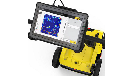
Output from the DSX with DXplore software showing tomographic image of detected underground utilities.
Machine Control Technology
Contact C.R. Kennedy to explore how the innovative Leica DSX Ground Penetration Radar can provide support with safety, management and automation of underground detection and mapping tasks. For more information or visit https://survey.crkennedy.com.au/undergrounddetectionsystems
Email: survey.crkennedy.com.au
Melbourne (03) 9823 1533
Sydney (02) 9552 8370
Brisbane (07) 3862 6210
Adelaide (08) 8410 1366
Perth (08) 9489 8500